Using the GIS system to motivate the investment in heritage
A System Dynamics Based Model
Arnaldo Vecchietti
arnaldo_vecchietti@comune.verona.it
One of the most important aspects of city management consists today in understanding which are the public projects with the highest return on investment.
There is always less public money to invest whilst the expectations of stakeholders and citizens have increased.
When the problem is how to decide how to invest in the city, we can find many good reasons to start the decision-making process in a System Dynamic model.
In the next pages I will give you some information on a recent project of the Office for the Enhancement of the Military architecture of the municipality of Verona (UVAM).
The UVAM office has been working for several years on an idea that it has wanted to bring to fruition for a long time: to disseminate knowledge about city military architectures previously unknown and underestimated, utilising GIS and GPS technologies, to give new opportunities to tourists visiting the city by increasing the number of attractors and to prolong the tourist season.
A) GEO-ECONOMIC SITUATION of VERONA• 261.701 inhabitants• Area: 206,63 km2 ; Density 1.254 ab./km2B) TOURISTS (in 2007)• Average stay: 2.6 days• Total: 3.200.000 presences
B) INTEREST of TOURISTS: Tourist flows are concentrated in the historic centre. The Opera season attracted in 2007 more than 500.000 people. Moreover, the visit tends to be limited to few places in the historic centre. Many tourists who stay on Lake Garda never see Verona!
The main objectives of our project are to encourage tourists to take alternative itineraries and to enhance unknown parts of the city and make them attractive throughout the whole year because military architectures can become important attractors in any season.
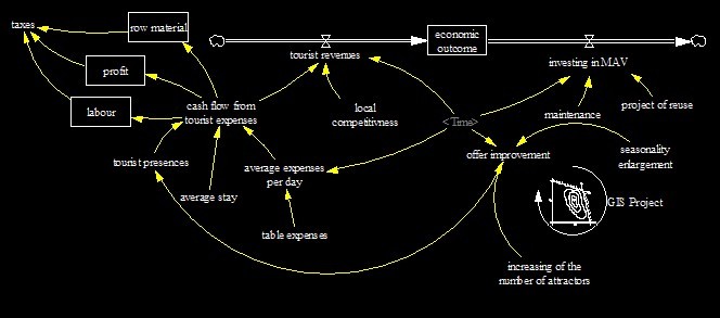
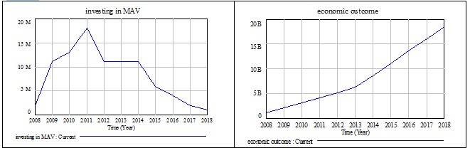
Investing in the reuse and maintenance of our Military Architecture is more convenient than any other kind of public investment in the city!
To invest 100 million euros in it can produce in a decade a global economic outcome of 20 billion euros!
The central idea of this project is to transform a geographical informative system into the start point of this huge urban project.
We decided to start the enhancement process from the informational side.
The prototype we are presenting here is a Geographical Information System (GIS) directly built by UVAM using Open Source software. The Military Architecture of Verona (MAV) heritage is a huge monumental system composed of 10 Km of walls, 19 forts and fortresses, monumental gates, ramparts, barracks, arsenals and so on. The MAV we can see today is what remains after two thousand years of defensive activity of Verona starting from the Roman period and going up to the Second World War period. The MAV has been for centuries an important part of the economy of the city and today, completely mismanaged and under evaluated, it runs the risk of becoming a marginal and degraded part of it. We are interested in using our GIS to enhance our MAV heritage by transforming it into one of the most interesting reasons to visit our city, along with Romeo and Juliet and the Arena.
AIMS:
1 to liberate the city centre of the concentration of tourists;
2 to create new tourist itineraries;
3 to re-direct tourists’ interest to the MAV, we hope to create private sector interest in it, which in turn will have beneficial results.
To achieve the previously mentioned aims, using the resources we have, we decided to focus our efforts on satisfying a niche of need of people who live in and visit Verona. So we decided to offer the tourists a free and fast tool to make their decisions regarding the planning and programming of their visit to our MAV simple and rewarding. To avoid misunderstanding the concept of the GIS we are using, I have to clarify it a bit. GIS is a Data Base (DB) of information from which it is possible to get a simplified, spatial representation of everything connected with DB.
So in our case we have a very high potential tool from which it is possible to extract a great quantity of high quality information.
However everything depends on our ability to design and implement the DB. The more we are able to understand what it’s to important to know to make more informed decisions, the more advantages we will be able to get from the GIS technology and help people in their day-to-day lives.
At the moment we have split our DB into two main sectors: MAV and Services and Commodities (SC). The MAV database is composed of the following parts: Walls, Gates, Towers, Forts, Fortresses, Barracks, Arsenals, Other military buildings. Each part is composed of various cards. Each card contains information on many informative fields. The SC database is composed of the following parts: Hotels, Bed and Breakfast, Public transport, Restaurants, Shops, Bars, Other services. We have invested a lot in the design, the organisation and cleaning of our DB.
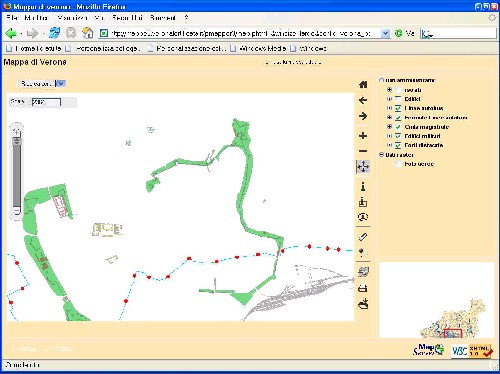
The quality of GIS depends heavily on the quality of DB. The process of geo referring data and locations is achieved by the use of Global Positioning System (GPS). All the information requested of the system is presented on a technical map of Verona territory on which all the topographical elements of the city (civic numbers, roads, squares, rivers, infrastructures, and so on) are highlighted. The output of our GIS is a geo referred map on which we can find the result of a question put to the DB. Quality of decision depends on quality of GIS So we could say that GIS is a decision support system involving the integration of spatially referenced data in a problem-solving environment. Our GIS, born, as a Geographical Information System has already become Geographical Information Services. Using a GIS doesn’t only mean using software. Adopting a work methodology is just as important! The map is not the GIS. The GIS is not the map. GIS is the system, which, thanks to an intelligent process of data storage, makes the representation of all the
tourist facilities and services ( car parks, lights, fire hydrants, phone boxes and so on) and tourist itineraries possible on demand.
OUTPUTS: so far the project has produced the prototype of GIS complete with the whole DB of geographic elements, the main part of the military architecture repository and some parts of the DB of services and commodities. The latter has not been completely updated yet. We are working on the storage data regarding: bus line stops, monuments, private activities like bars, restaurants, hotels, other public services like hospitals, chemists, police stations and so on. We have foreseen finishing the storage data at the basic level in not more than six to ten months. The reports we can obtain today from the GIS contain historical and technical (architectonic) information linked to geographical and some socio-economical activities. For instance, today, we can link in a geographical way (on a map) approximately 100 Manu facts of our MAV, a couple of suggested itineraries which link 30 attractors; we can also find all the closest bus line stops, some restaurants and bars to the attractors, complete with details of prices, timetables, distances and street locations. In the near future we would like to enlarge the number of activities presented in the DB, improving also the range of information deliverable.
ACHIEVEMENTS: the job has required the collaboration of different offices (internal and external to the municipality) The internal ones are discovering the relevance of the quality of their DB. People are more aware today than they were months ago that the more relevant results for clients come from the organisational process of the whole Town Hall. The external actors to the municipality like the tourism promotional office (managed by the Provincia) or the tourism agencies (managed by private people) are now becoming interested in GIS because they understand that with this tool they can supply a more comprehensive service to the tourist, tailored and on demand. There are also other positive aspects we have to consider. First of all we can now observe a very new phenomenon: tourists (but also some Veronese) are discovering the MAV as a monument, also in the more derelict parts of the city. They have appreciated having access to a site like www.veronafortificata.it. and being able to find out who built an MAV, and when, why, and how it was important to the city. This has highlighted a part of the city which was before neglected by the majority and is slowly becoming more interesting for people. Linked with this enhancement of the attractiveness of our MAV via informative service, there is an interest on the part of some “entrepreneurs of spare time” who are interested in setting up a commercial activity close to a MAV. We hope this is the start of a virtuous circle of investments. We know it is too early to consider this experience as a success but we think it will be!
NEGATIVE ASPECTS: is difficult to find negative aspects in what we are doing with our GIS. However, we have to consider that it is important for the implementer to show effective and convenient results to people in a reasonable period of time. Differently, it takes so long to completely implement a job like the one we are doing, that it is very easy to forget that you are setting up a real service, transforming it into an endless search for perfection. So potentially the negative aspects could be:
1. to manipulate the interests of tourists without giving them a real customised easy
tool to use, burning in this way an opportunity to mix cultural tourism and local
development;
2. to ignore the effectiveness of the project in terms of users’ satisfaction;
3. to neglect to monitor the effect of GIS on the visits, and
4. to exclude the private sector in the GIS project.
Never forget that the first results have to be evident to the people in a reasonable period of time.
Future steps:
SHORT TERM: to officially open the GIS section of www.veronafortificata.it
To complete the main itineraries.
MID TERM: to complete the DB storage of Services and Commodities data
LONG TERM: to manage the quantity of data, which can be unlimited. Eventually, there could be the chance to try to create a self-sustainable project by requesting a small fee from those who benefit from being mentioned on the site (for instance public transport, bars, shopkeepers, etc)
Approach and procedures
Our GIS is today part of the site www.veronafortificata.it. The GIS could become the portal of the city, a portal in which to place a dedicated section on MAV. We are opening a debate on this subject. After the elections we will receive answers on this topic. From today people interested in knowing the MAV better can use this tool by going to the site. Our GIS can be used as a Decision Support System. In this case it could be used to take decisions on a tourist tour, which regard the whole or a part of the MAV.
Functionaries at the Town Hall can also use it to decide what is better in many management activities regarding MAV (about maintenance, check users, finding new uses for it, and so on). Although GIS can have many uses we limit now our description to something already possible)
PROCEDURE First page presents on the right side a menu, which can help the visitor to highlight some elements of GIS. After having marked the menu voice and refreshed the page the requested informative layer appears. At any time it is possible to ask the system questions by the use of a specific little frame on the left side. To avoid problems in understanding where you are on the map it’s possible to contextualize what you are looking at in the frame placed at the bottom right side of the page.
PROCESS: to build and to maintain the GIS is a team job. Coordination and communication are very important.
The setting up process involves a linkage of many activities. From the design of DB to gathering data, from writing itineraries to finding the necessary information, from information technology to journalistic aspects. We have decided to proceed with the implementation in a parallel way, instead of doing one step at a time. In doing this, we have not finished anything yet, but we are very close to making everything available on the website (maps, itineraries, reports, useful information).
BASIC STEPS followed: To design DB To obtain the collaboration with other offices, To
obtain and georefer the maps, To go out to do the research with GPS, To write cards for each attractor, To involve experts to check cards. To use open source programmes.
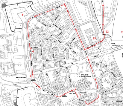
An itinerary is a path which links some elements of MAV in a way that represent a sort of thematic collection. This collection allows people to understand what a zone of the city can offer in terms of MAV heritage. Following the itinerary, highlighted in red on the map, people can find a lot of information on things represented by numbered dots. Moreover people can ask the system questions and receive information about information stored in DB, like for example: bus stops, restaurants, bars, and so on. Itineraries and geo referred maps are downloadable or printable. In this way people can use it with laptop or iPaq pocket PC. Itineraries are georeffered and so are usable with GPS devices.
You can ask the system precise questions. For example you can find the nearest bus stop of a bus line to a location specifying the distance. After receiving an answer you can navigate to the linked DB and see the timetable for that bus stop. Other similar options will be ready in a few months. So in the same easy way it will be possible to find a restaurant on the basis of distance, prices, menu and so on. The same will be possible for the other fields we will be able to open from the City Hall DB’s.
All the elements of our MAV system included in the Military Architecture DB have been already georeferred. So it’s now already possible to see reports like the one you are seeing by clicking on a point of interest on the map. Today the report can give information on the artefact highlighted: who the planner, designer, orderer was, when it was built, who the actual owner and user is. It’s possible also to have a short description from an architectural and structural point of view and a historical description regarding function, garrison and armaments. The description ends with a short report on the maintenance of the Manu facts.
We have to advertise our new tool, which can really help people to achieve their aims, be they tourists or people interested in taking advantage of the enhancement process of our MAV heritage. Results ought to be monitored and used to find new resources to pay to improve the GIS. Maybe new resources will be found to maintain our MAV because it will become evident that MAV can represent a new tourist attraction for the city. Maybe private investors will become aware of the importance of our MAV to enlarge and to extend the tourist season in Verona.
THREATS: the upcoming elections will say whether there will be the will to continue with political support of the UVAM and its activities. A real risk we run is that the success of the first step of GIS implementation won’t be followed by a new mandate and new resources for UVAM. In any case if we aren’t able to involve the private sector in the project the huge dimension of the activities we have to manage to sustain the system will be too much for us. In fact the virtuous circle we can activate convincing tourists to visit our AMV can collapse if our AMV isn’t well maintained and reused. Maybe we will be able to motivate many tourists to visit for the first time our MAV for the reason of their beauty and romantic charm but to stabilize a flow of tourists we have to give them more than we can
We think this project has an easy transferability: thanks to the use of open source software (Map server, P.Mapper etc) we are free to eventually involve other partners without asking money for software. In this way the only earner will be the Manu facts and the people who will invest in it. To have positive results the public authority requires that there is a real change in the attitude in considering heritage as an important element of local development. In this new approach we have also considered the tourist as a part of the solution. In fact if we have important parts of our cities that are completely neglected and a city centre full of tourists, it is easy to understand that we must change something. The assumption from which we started was that we have too many tourists in the city centre for too short periods, and many attractors in the periphery with nobody interested in them. The GIS project would solve this contradiction. GIS uses the DB of Town Hall (and in future of the private companies involved in the project) to share useful information with the aim of decentralising tourist flows in Verona. To guarantee the sustainability of the project it is indispensable to involve the private sector and share advantages among all the actors of the system.
This has to be done respecting the monumental value of the MAV ensuring that the public can find the needed resources to carry on the project and that the private investor enjoys advantages from investing in heritage. Taking a look at the “taxes and profits” evolution entrances (simulated) it looks like an absolutely sustainable project!
|